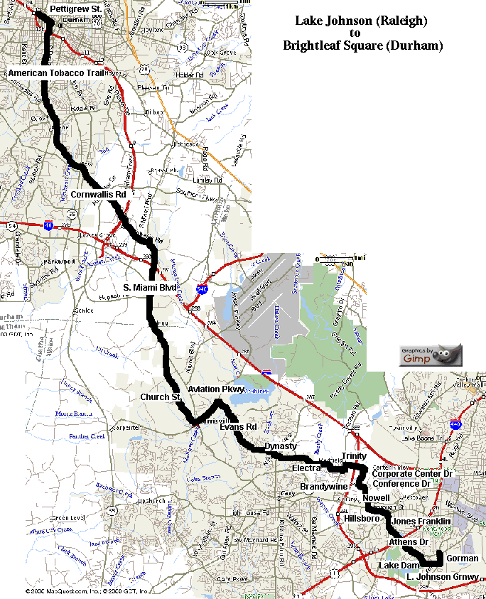
At the intersection of Gorman Street (I-40 Exit 295) and Avent Ferry
in Raleigh, between NC State Centennial Campus and Lake Johnson.
Breakfast is available at Hardee's or Courtney's.
| Avent Ferry Shopping Center | |||
|---|---|---|---|
| 0.0 | R | 0.1 | Gorman St |
| 0.1 | R | 0.8 | Lake Johnson Greenway |
| (slow, respect Pedestrians & Skaters) | |||
| 0.9 | R | 0.4 | Lake Dam Rd (climb!) |
| 1.3 | L | 0.1 | Avent Ferry |
| 1.4 | R | 1.2 | Athens Dr |
| - | cross I-440 US 1/64 (bridge) | ||
| 2.6 | R | 0.4 | Jones Franklin Rd |
| 3.0 | L | 0.6 | Hillsborough |
| (Stop at Mamta Emporium for Samosas?) | |||
| 3.6 | R | 0.7 | Nowell |
| (4.0) | - | cross NC 54 / Chapel Hill Rd | |
| 4.3 | L | 0.2 | Conference Dr |
| 4.5 | R | 0.5 | Corporate Center Dr |
| Hills between Trinity and Aviation Pkwy! | |||
| 5.0 | L | 1.0 | Trinity |
| - | cross I-40 (bridge) | ||
| Trinity takes a sharp left.
High traffic + poor visibility = be careful! | |||
| 6.0 | R | 1.6 | Brandywine (becomes Electra Dr) |
| 7.6 | - | 0.6 | cross Reedy Creek Rd (becomes Dynasty) |
| 8.2 | - | 0.9 | cross Harrison (becomes W. Dynasty) |
| 9.1 | R | 1.9 | Evans Rd |
| (9.6) | - | cross Cary Pkwy | |
| (10.4) | - | cross Weston Pkwy | |
| - | cross West end of Lake Crabtree (bridge) | ||
| 11.0 | L | 1.0 | Aviation Pkwy |
| End of hills! | |||
| 12.0 | 0.1 | cross NC 54 (becomes Morrisville Carpenter) | |
| - | cross Church St | ||
| 12.1 | R | Morrisville Town Hall (take a break) | |
| L | 0.1 | Morrisville Carpenter | |
| 12.2 | L | 3.6 | Church St |
| 15.8 | L | 1.0 | NC 54 |
| 16.8 | - | 1.4 | S. Miami Blvd (NC 54 turns Left at Page Rd) |
| (17.4) | - | cross I-40 (bridge) | |
| 18.2 | L | 4.5 | Cornwallis |
| - | cross Durham Freeway/147 (bridge) | ||
| - | cross Alston Ave | ||
| (21.4) | - | cross NC 55 | |
| 22.7 | R | 3.3 | The American Tobacco Trail |
| slow, respect Pedestrians & Skaters) | |||
| (24.0) | - | cross Fayetteville Rd | |
| (24.9) | - | cross Roxboro St (bridge) | |
| - | cross Lakewood (bridge) | ||
| 26.0 | 0.2 | becomes Blackwell Rd Bike Lane | |
| - | cross Durham Freeway/147 (underpass) | ||
| 26.2 | L | 0.3 | Pettigrew St. |
| 26.5 | L | 0.1 | Chapel Hill St |
| 26.6 | R | 0.1 | Duke St |
| 26.7 | L | 0.1 | Pettigrew St. |
| 26.8 | to Brightleaf Square | ||