(1st left; immediate right)
(Underwood Grocery at New Sharon Ch Rd.
is the last services for 24 miles)
Two stores: Leasburg Gro. & 4-Points Grill
cross N. Hyco Creek
North Road Bicycle Co.
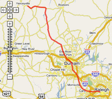
Yanceyville, NC
| NCSU (Raleigh NC) |
Go to the Bikely / Google Interactive Route Map
|
|||
| AT | TURN | GO | ON | |
|---|---|---|---|---|
| Raleigh | ||||
| 0.0 | W | 1.7 | NCSU Hillsborough St toward Cary (go west) | |
| 1.7 | L | 1.4 | Beryl Rd | |
| 3.1 | R | 0.1 | Powell Dr | |
| 3.2 | L | 3.4 | Hillsborough / NC-54 | |
| 6.6 | BR | 0.1 | Durham Rd | |
| Cary | ||||
| 6.7 | L | 0.4 | Ward St and R on Cedar St (1st left; immediate right) | |
| 7.1 | R | 0.3 | Academy | |
| 7.4 | L | 3.5 | Chapel Hill Rd | |
| Morrisville | ||||
| 10.9 | L | 0.1 | Morrisville Carpenter Rd | |
| 11.0 | R | 3.5 | Church St | |
| 14.5 | L | 1.0 | Miami Blvd / NC-54 | |
| RTP | ||||
| 15.5 | - | 1.4 | TRO Miami Blvd | |
| 16.9 | L | 4.4 | Cornwallis Rd | |
| Durham | ||||
| 21.3 | R | 3.2 | American Tobacco Trail | |
| 24.5 | L | 0.5 | Blackwell St (go under the Freeway) | |
| 25.0 | L | 0.1 | Main St | |
| 25.1 | R | 0.1 | Morris St | |
| 25.2 | L | 0.5 | Morgan St (one-way traffic) | |
| 25.7 | R | 0.8 | Main / US-70 | |
| 26.5 | R | 0.2 | 9th St (need an ATM? food?) | |
| 26.7 | L | 2.0 | Hillsborough Rd (go over 15-501) | |
| 28.7 | R | 4.5 | Cole Mill Rd (go under I-85, cross the Eno) | |
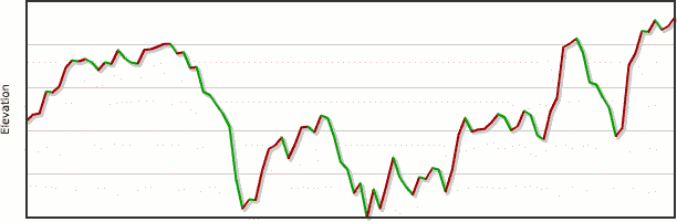
| 33.2 | R | 3.7 | Pleasant Green Rd (biggest hill!) | |
| 36.9 | X | 7.8 | St Mary Rd becomes Schley Rd (Underwood Grocery at New Sharon Ch Rd. is the last services for 24 miles) | |
| 44.7 | R | 1.0 | Walnut Grove Ch Rd (cross creek) | |
| 45.7 | L | 7.8 | Wilkerson Rd | |
| 53.5 | - | 5.9 | becomes Wheeler's Ch Rd | |
| 59.4 | - | 2.2 | becomes Gordonton Rd | |
| 61.6 | L | 8.6 | Leasburg Rd US-158 Two stores: Leasburg Gro. & 4-Points Grill cross N. Hyco Creek | |
| 70.2 | R | 3.1 | NC-86 (Cross Roanoke River Basin) | |
| 73.3 | L | 0.9 | Main St / NC-62 | |
| 74.2 | L | 0.1 | North Ave | |
| 74.3 | - | A.H. Motz Building | ||
|
| ||||