| Amtrak Station (Greensboro NC) |
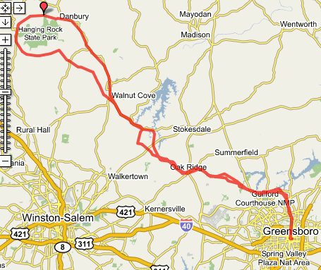
Go to the Bikely / Google Interactive Route Map

|
| AT | TURN | GO | ON |
|---|
| | | 0.0 | Greensboro Amtrak |
| 0.0 | W | 0.2 | Washington St (go west) |
| 0.2 | R | 5.9 | Elm St (alt: Church St) |
| 6.1 | - | 0.5 | through roundabout onto Bass Chappel Rd |
| 6.6 | L | 2.5 | Regent's Park Ln
(a neighborhood street) |
| 9.1 | L | 0.5 | Lake Brandt Rd |
| 9.6 | R | 1.3 | Old Battleground (2340) |
| 10.9 | - | 0.7 | becomes Horse Pen Creek Rd |
| 11.6 | R | 1.8 | Carlson Dairy Rd (Greensboro CC) |
| 13.4 | L | 0.3 | Pleasant Ridge Rd (store)
BR TRO Pleasant Ridge Rd
(NOT Lewiston) |
| 13.7 | R | 1.1 | Stanley Huff Rd |
| 14.8 | L | 3.4 | Bunch Rd |
| 18.2 | L | 1.5 | Oak Ridge Rd (NC-150)
Cross NC-68; Wendy's, Supermarkets, etc. |
| 19.7 | R | 2.1 | Linville Rd |
| 21.8 | L | 0.2 | Haw River Rd |
| 22.0 | R | 2.6 | Goodwill Ch Rd (Guilford)
becomes Freeman Rd |
| 24.6 | L | 0.1 | Piney Grove Rd |
| 24.7 | R | 2.1 | Goodwill Ch Rd (Forsyth) |
| 26.8 | R | 1.7 | Belews Creek Rd |
| 28.5 | L | 5.1 | NC-65 |
| 33.6 | R | 0.0 | Stokesburg Rd
Cross RR Tracks |
| 33.6 | R | 0.5 | Main St (NC-89/US-311) Walnut Cove
Restaurants, ABC Store |
| 34.1 | L | 6.5 | 3rd St (Walnut Cove)
BR becomes Piney Mountain Rd |
| 40.6 | R | 0.6 | NC-8 |
| 41.2 | L | 1.0 | Flat Shoals Rd
(S. Stokes VFD) |
| 42.2 | R | 0.9 | TRO Flat Shoals Rd |
| 43.1 | BL | 4.5 | TRO Flat Shoals Rd
(Scenic view of Hanging Rock on the right) |
| 47.6 | BR | 0.5 | (2nd) Covington Rd 2008 |
| 48.1 | BR | 0.8 | Capella School Rd |
| 48.9 | BR | . | NC-66 climb through the pass
between HR and Sauratown.
Convenience store |
| At 49.4 you could turn left onto the very scenic Taylor Rd for bonus miles or to climb Sauratown |
| 50.0 | R | 5.3 | Moore's Spring Rd |
| 55.3 | R | - | Hanging Rock SP Rd.
IF going up! |
| 55.3 | R | 1.6 | Moore's Spring Rd
East, toward Danbury |
| 56.9 | R | 5.0 | NC-8/NC-89 |
| 61.9 | BL | 6.9 | TRO NC-89 (NOT 8) joins US-311
then becomes Main St in Walnut Cove |
| 68.8 | L | 0.0 | Stokesburg Rd
Cross RR Tracks |
| 68.8 | L | 5.1 | NC-65 |
| 73.9 | L | 0.4 | Belews Creek Rd TRO NC-65 |
| 74.3 | R | 0.8 | TRO Belews Creek Rd / NC-65 |
| 75.1 | R | 1.7 | Kernersville Rd |
| 76.8 | R | 1.0 | becomes Piney Grove Rd |
| 77.8 | L | 2.6 | Freeman Rd
becomes Goodwill Ch Rd |
| 80.4 | L | 0.2 | Haw River Rd |
| 80.6 | R | 2.1 | Linville Rd |
| 82.7 | L | 1.7 | Oak Ridge Rd (NC-150) |
| 84.4 | R | 0.7 | Bunch Rd |
| 85.1 | BR | 2.7 | TRO Bunch Rd |
| 87.8 | R | 1.1 | Stanley Huff Rd |
| 88.9 | L | 0.3 | Pleasant Ridge Rd (Store) |
| 89.3 | R | 1.8 | Carlson Dairy Rd (NOT Lewiston)
(Greensboro CC) |
| 91.1 | L | 0.7 | Horse Pen Creek Rd |
| 91.8 | - | 1.3 | becomes Old Battleground (2340) |
| 93.1 | L | 0.5 | Lake Brandt Rd |
| 93.7 | R | 1.4 | Regent's Park Ln |
| 95.1 | R | 0.7 | Bluff Run Dr |
| 95.8 | L | 0.3 | Lake Jeanette Rd |
| 96.1 | R | 5.9 | (through roundabout) Elm St (alt: Church St) |
| 102.0 | L | 0.2 | Washington St |
| 102.2 | R | 0.0 | Greensboro Amtrak |
